The Inner Khavasak
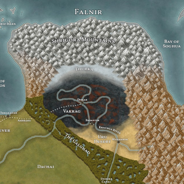
The Inner Khavasak is a land marred by blight and devastation. Screened on the north and east by the Shrigora Mountains, the largest range in Aios, and on the south and west by the Galghad, a vicious swamp filled with nightmarish plant and animal life bred specifically to deter invaders. Should a traveler brave their way through a handful of closely watched roads into the interior, they would find a land that still bore many of the scars of the Saklugz’s arrival, wounds which only continue to fester as the Dark God continuously strips the region dry of it’s material resources. To the south, there is the Uru Desert, a vast, desolate wasteland peopled by a handful of hostile tribes. To the north, one finds the Thurka, a frozen tundra where only the fiercest beings can survive. In the middle is the Vakrag, Nezlugz for “flaming kettle”, which, befitting it’s name, is covered in with craters and volcanic geysers from the centuries of destructive mining and Zuthruhk magic. Despite the inhospitable landscape of the Inner Khavasak, it is home to some of the largest cities in Aios. Besides Wunakros and Eksantir, you will find Dissak, the capital of the Dark God’s empire, along the banks of the Krachga River.
The Outer Khavasak, North/Central

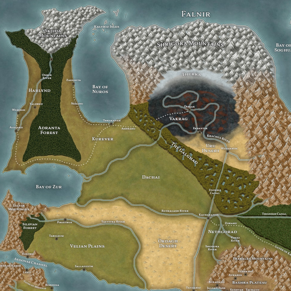
Traveling west from the Inner Khavasak, one will first pass through Kurever and the Dachai. Nicknamed “the breadbasket of the Khavasak”, these two regions play a vital role in feeding the Dark God’s empire. While Kurever deals almost exclusively in the cultivation of cereal grains, the Dachai is a bit more varied, incorporating luxury goods like grapes and olives in addition to dietary staples. Continuing west, you will reach Harlynd, a comparatively recent acquisition into the Khavasak. While the principle industry of the region has traditionally been its robust fishing industry, Saklugz’ deforestation of the Adranta Forest has created large swathes of farmland that the Dark God has begun giving to soldier-settlers retired from the Ukni. Heading south, one will eventually reach the Ordagh Desert, a once fertile land that now acts as a buffer between the Khavasak and the city states of Naviras. Moving east along the Runkalash River, one would pass through the large metropolis of Kacharanos before reaching the Nethgorad: a region mainly known for the large, slave-tilled plantations fed by the Shodura and Vozai rivers.
The Outer Khavasak, South
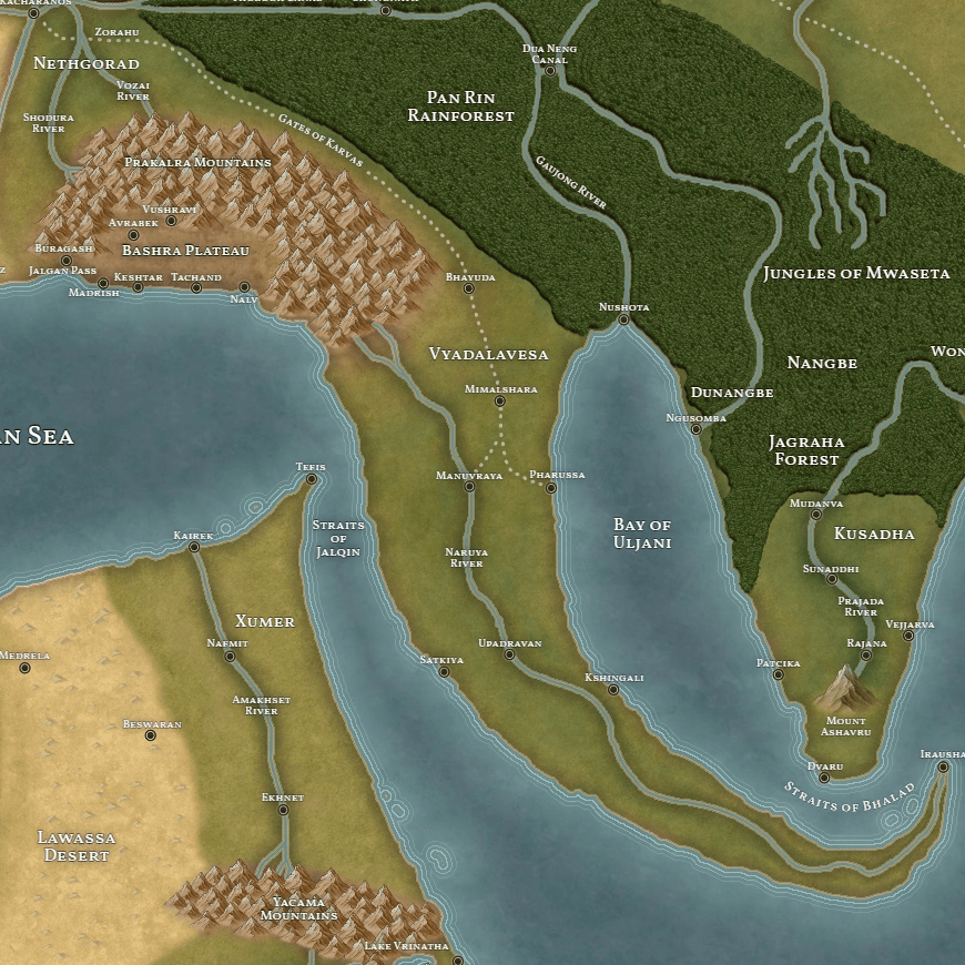
If one were to travel south from Kacharanos along the Zorahu, after skirting through the Gates of Karvas: a long, narrow pass between the Prakalra Mountains and the Pan Rin Rainforest, you would reach the Vyadalavesan subcontinent. This region has an extremely hot, tropical climate, with lush forests fed by the Naruya River. While there remain certain cultural similarities between Vyadalavesa, Kusadha, and Datyavam, the centuries of occupation have drastically changed Vyadalavesan society, turning it into something of a hybrid culture. Crossing the Straits of Jalqin into Xumer, you would find another river valley civilization, with dozens of large cities along the banks of the Amakhset River, surrounded by the nearly impassible Yacama Mountains and Lawassa Desert.
Northwest Falnir
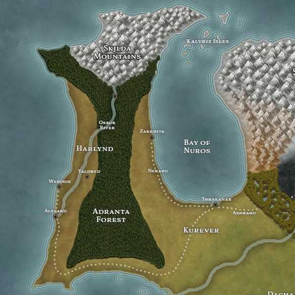
In the northeast of Aios you will find the Skjlda Mountains, a snow covered landscape home to a variety of polar and sub-polar life forms, including Skirmisher Trees and the dreaded Ambusher Bear. Traveling south, you would cross into the Adranta Forest, an ancient land with one of the most distinctive ecosystems in all Aios. Not only does this include such unique species as the Hornstalker and Bloodvein Tree, but also the Lithir: powerful forest spirits who give even Saklugz pause.
Naviras
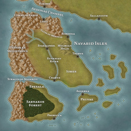
The Navarid Isles are home to a collection of independent, often mutually hostile city-states. These city-states function under a variety of different governments, including democracies (Boronea, Aegerea), monarchies (Lyst), and everything in between (like Stakalphis’ monarcho-oligarchy). The Pythikas Mountains run along the western coast of both Iores and Epesala, the two largest Navarid Isles. While most of Epesala is covered by the Sarnakos Forest, Iores is home to a large number of cities, particularly in the alluvial plains around the Eunesian River.
Traveling north, you will find the vast Velian Plains stretching far to the north and east, with the Lianin Mountains and Silipian Forest to the west. While many of the city-states of the Velian Plains exercise some nominal autonomy in day to day governance, the entire region is under the military hegemony of Piristrus, a bastion against the Ukni along the Taevitra River.
Bashra
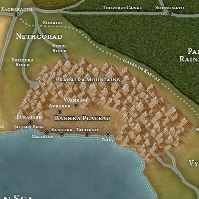
An isolated bastion of resistance against the Dark God, the Bashra Plateau is home to a number of independent city states. This includes Buragash, the region’s largest military power, and Tachand, the last Sheniv-ruled city. The Bashra Plateau’s isolation, with the Jalgan Pass near Buragash and the port cities on the Nostrean Sea being the only major points of entry, has allowed the region to continue resisting Saklugz’ persistent incursions while neighbors like Vyadalavesa and Xumer have fallen into the Khavasak. Rich ore deposits, and the associated mining settlements of Avrabek and Vushravi, contribute to Bashra’s wealth, which in turn gives it the means to continue standing against the Dark God’s ceaseless raiding.
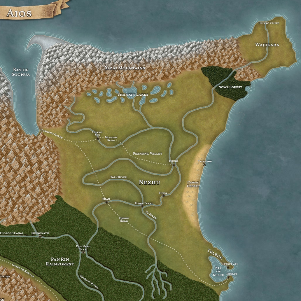
Nezhu

Far to the east lies the Nezhuan Empire. The largest single political entity opposing the Dark God, the Nezhuan Emperor controls territory stretching from the evergreen Nowa Forest and the gigantic waterfalls of Wajukara in the north to the Cawau Desert and Pan Rin Rainforest in the south. The Nezhuan heartland is comprised of the massive, alluvial plain created by the twin rivers of Yaln and Zu, with the Shanxin Lakes to the north, in the foothills of th Xizai Mountains. Saklugz has long recognized Nezhu as the greatest threat to his empire, and because of that the two powers have been at near-constant war: either outright or through the use of raiding and soft power in contested areas such as the Pan Rin Rainforest or the Bay of Soghua.
Southeast Falnir
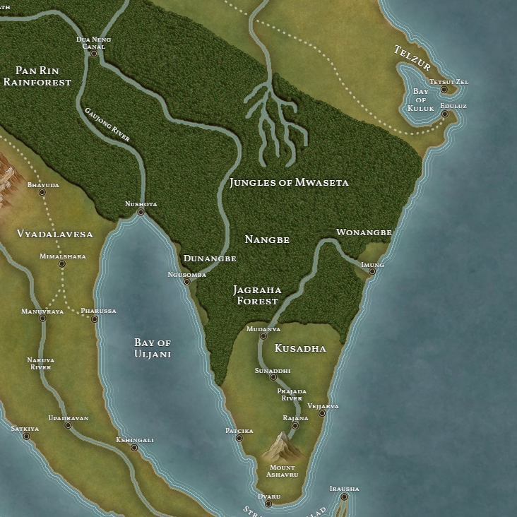
In southeast Falnir, the Pan Rin rainforest extends south into a massive forest system that includes both the Jungles of Mwaseta and the Jagraga Forest. Along the coast to the east and west of Mwaseta are the kingdoms of Dunangbe and Wonangbe. While there are many cultural similarities between these two coastal kingdoms, geopolitical realities have shaped them into vastly different environments. To the west, the kingdom of Dunangbe has been beset by a brutal campaign of slaving, raiding, and warfare by privateers and mercenaries payed from the Dark God’s coffers. By contrast, the eastern kingdom of Wonangbe has had a comparatively stable existence as far away from the Dark God’s power as anywhere on Aios. At the southeastern tip of Falnir, you will find Kusadha, a region culturally connected to Vyadalavesa and Datyavam whose kings continue to hold out against the Dark God after centuries of struggle.
Ilroin
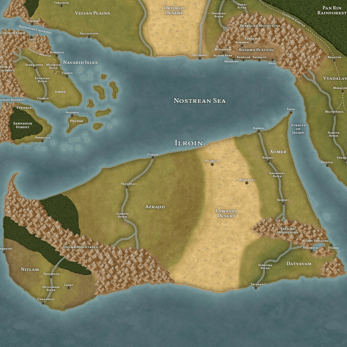
In the center of Ilroin, one will find the kingdom of Azrajid. While the Zarakis River and the many cities along it’s banks act as the region’s heartland, the vast swathes of horse country surrounding the Zarakis valley have led to a strong cavalry culture amongst the Azrajin that is justly renowned across Aios. To the southwest is the land of Nitlam, a diverse region with a number of independent cities along the banks of the Hetelwasa River, while a large steppe region in the interior plays host to a number of tribal groups. To the southeast, nestled between the Yacama Mountains and the Lawassa Desert, is Datyavam. Datyavam’s geographic isolation has culturally screened it from the rest of Ilroin, while it’s strong maritime tradition has seen it develop ties with Kusadha and Vyadalavesa. Along the eastern coast of Datyavam is Lake Vrinatha, whose eastern and western shores hold the cities of Etadrina and Utarja, two of the most important settlements in the region.